Stoney Hill Loop
Stoney Hill Regional Park. Vancouver Island. #Hiking #Loop #StoneyHill #Vancouver
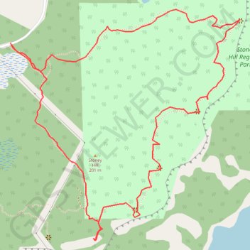
- Distance: 3.7 Km
- Elevation gain: 185 m
- Maximum elevation: 201 m
- Elevation loss: 185 m
- Minimum elevation: 133 m
Interactive trail map
Trail profile
- Distance: 3.7 Km
- Elevation gain: 185 m
- Maximum elevation: 201 m
- Elevation loss: 185 m
- Minimum elevation: 133 m
About this trail
Name: Stoney Hill Loop trail, distance, elevation, map, profile, GPS track
Coordinates: 48.77644 -123.57930 48.78428 -123.56751
Other hiking, mountain biking, running and outdoor activity trails
Click on a trail to view its statistics, map and profile.
BBF loop to the Skydeck in Nanaimo
Canada > British Columbia > Cowichan Valley Regional District > Area A (Mill Bay / Malahat) > Mill Bay
BBF loop to the Skydeck
Distance: 323.5 Km • Elevation gain: 6,222 m • Maximum elevation: 706 m