Thank you for supporting this site ❤️
Make a donation
Make a donation
Gear up for your next adventure:
🆘Personal Locator Beacons (PLB) - Satellite emergency beacons for life-saving help in areas with no mobile coverage
As an Amazon Associate, this site earns from qualifying purchases at no extra cost to you.
Mississauga River Loop
Kawartha Highlands Signature Site. #Hiking #Snowshoeing #Loop #Kawartha
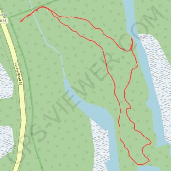
- Distance: 1.6 Km
- Elevation gain: 8 m
- Maximum elevation: 251 m
- Elevation loss: 8 m
- Minimum elevation: 245 m
Interactive trail map
Thank you for supporting this site ❤️
Make a donation
Make a donation
Gear up for your next adventure:
As an Amazon Associate, this site earns from qualifying purchases at no extra cost to you.
Trail profile
- Distance: 1.6 Km
- Elevation gain: 8 m
- Maximum elevation: 251 m
- Elevation loss: 8 m
- Minimum elevation: 245 m
Thank you for supporting this site ❤️
Make a donation
Make a donation
Gear up for your next adventure:
As an Amazon Associate, this site earns from qualifying purchases at no extra cost to you.
About this trail
Name: Mississauga River Loop trail, distance, elevation, map, profile, GPS track
Coordinates: 44.57296 -78.35911 44.57719 -78.35420
Thank you for supporting this site ❤️
Make a donation
Make a donation
Gear up for your next adventure:
As an Amazon Associate, this site earns from qualifying purchases at no extra cost to you.
Other hiking, mountain biking, running and outdoor activity trails
Click on a trail to view its statistics, map and profile.