Thank you for supporting this site ❤️
Make a donation
Make a donation
Gear up for your next adventure:
As an Amazon Associate, this site earns from qualifying purchases at no extra cost to you.
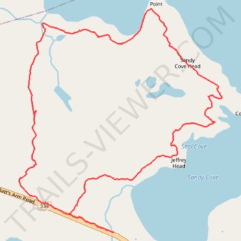
Turpin's Trail West
- Distance: 5.1 Km
- Elevation gain: 55 m
- Maximum elevation: 26 m
- Elevation loss: 58 m
- Minimum elevation: 0 m
- Moving time: 1 h 43 m
- Moving speed: 3.0 Km/h
- Maximum speed: 10.5 Km/h
- Total time: 1 h 47 m
- Global speed: 2.9 Km/h
Interactive trail map
Thank you for supporting this site ❤️
Make a donation
Make a donation
Gear up for your next adventure:
As an Amazon Associate, this site earns from qualifying purchases at no extra cost to you.
Trail profile
- Distance: 5.1 Km
- Elevation gain: 55 m
- Maximum elevation: 26 m
- Elevation loss: 58 m
- Minimum elevation: 0 m
- Moving time: 1 h 43 m
- Moving speed: 3.0 Km/h
- Maximum speed: 10.5 Km/h
- Total time: 1 h 47 m
- Global speed: 2.9 Km/h
Thank you for supporting this site ❤️
Make a donation
Make a donation
Gear up for your next adventure:
As an Amazon Associate, this site earns from qualifying purchases at no extra cost to you.
About this trail
Name: Turpin's Trail West trail, distance, elevation, map, profile, GPS track
Start: Joe Batt's Arm Road, Tilting, Newfoundland, Newfoundland and Labrador, Canada (49.70949 -54.08815)
End: Joe Batt's Arm Road, Tilting, Newfoundland, Newfoundland and Labrador, Canada (49.70849 -54.08440)
Coordinates: 49.70848 -54.09235 49.72058 -54.07533
Thank you for supporting this site ❤️
Make a donation
Make a donation
Gear up for your next adventure:
As an Amazon Associate, this site earns from qualifying purchases at no extra cost to you.