Import a GPX file

Southeast French Park Loop Walk

  • Distance: 4.1 Km
  • Elevation gain: 86 m
  • Maximum elevation: 260 m
  • Elevation loss: 84 m
  • Minimum elevation: 206 m
  • Moving time: 1 h 25 m
  • Moving speed: 2.9 Km/h
  • Maximum speed: 5.5 Km/h
  • Total time: 2 h 52 m
  • Global speed: 1.4 Km/h

Interactive trail map

Trail profile

  • Distance: 4.1 Km
  • Elevation gain: 86 m
  • Maximum elevation: 260 m
  • Elevation loss: 84 m
  • Minimum elevation: 206 m
  • Moving time: 1 h 25 m
  • Moving speed: 2.9 Km/h
  • Maximum speed: 5.5 Km/h
  • Total time: 2 h 52 m
  • Global speed: 1.4 Km/h

About this trail
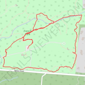
Name: Southeast French Park Loop Walk trail, distance, elevation, map, profile, GPS track

Start: Section Road, Brookwood, Amberley Village, Hamilton County, Ohio, 45236, United States (39.19812 -84.42435)

End: Section Road, Brookwood, Amberley Village, Hamilton County, Ohio, 45236, United States (39.19756 -84.42482)

Coordinates: 39.19537 -84.42786 39.20095 -84.41823

Gear up for your next adventure:

👟Lightweight Trail Runners - Agile footwear for fast movement over rugged Australian terrain
🧭Global Orienteering Compass - High-precision liquid-filled compasses for accurate map reading and navigation
🖼️Scratch-off Australia Map - Track the regions and peaks you have explored geographically
🧯Animal Deterrent Spray - Safety spray for wildlife
🏫Topographic World Globes - 3D physical relief globes to understand global geography

As an Amazon Associate, this site earns from qualifying purchases at no extra cost to you.