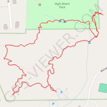
High Desert Loop
Loop hike to High Desert Park by High Desert Trail and Joedy's Trail. #Hiking #Loop #Desert #Park
- Distance: 2.4 Km
- Elevation gain: 62 m
- Maximum elevation: 659 m
- Elevation loss: 62 m
- Minimum elevation: 624 m
- Moving time: 1 h 1 m
- Moving speed: 2.4 Km/h
- Maximum speed: 9.3 Km/h
- Total time: 1 h 37 m
- Global speed: 1.5 Km/h
Interactive trail map
Trail profile
- Distance: 2.4 Km
- Elevation gain: 62 m
- Maximum elevation: 659 m
- Elevation loss: 62 m
- Minimum elevation: 624 m
- Moving time: 1 h 1 m
- Moving speed: 2.4 Km/h
- Maximum speed: 9.3 Km/h
- Total time: 1 h 37 m
- Global speed: 1.5 Km/h
About this trail
Name: High Desert Loop trail, distance, elevation, map, profile, GPS track
Coordinates: 34.05266 -112.15475 34.05645 -112.14929