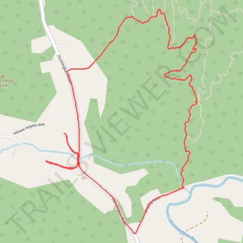
Cochrans trails
- Distance: 6.8 Km
- Elevation gain: 277 m
- Maximum elevation: 387 m
- Elevation loss: 278 m
- Minimum elevation: 155 m
- Moving time: 46 m 48 s
- Moving speed: 8.8 Km/h
- Maximum speed: 18.9 Km/h
- Total time: 46 m 48 s
- Global speed: 8.8 Km/h
Interactive trail map
Trail profile
- Distance: 6.8 Km
- Elevation gain: 277 m
- Maximum elevation: 387 m
- Elevation loss: 278 m
- Minimum elevation: 155 m
- Moving time: 46 m 48 s
- Moving speed: 8.8 Km/h
- Maximum speed: 18.9 Km/h
- Total time: 46 m 48 s
- Global speed: 8.8 Km/h
About this trail
Name: Cochrans trails trail, distance, elevation, map, profile, GPS track
Coordinates: 44.36250 -73.00296 44.37876 -72.98758
Other hiking, mountain biking, running and outdoor activity trails
Click on a trail to view its statistics, map and profile.
Joy Ride, Richmond
United States > Vermont > Chittenden County > Richmond
Distance: 11.7 Km • Elevation gain: 193 m • Maximum elevation: 293 m