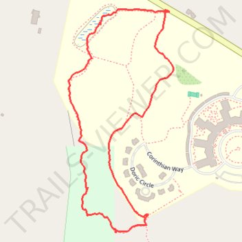
Walking the northeast part of Overlook's trails
Though toward the end the way we took really wasn't a trail anymore.
- Distance: 1.9 Km
- Elevation gain: 41 m
- Maximum elevation: 272 m
- Elevation loss: 40 m
- Minimum elevation: 245 m
- Moving time: 46 m 12 s
- Moving speed: 2.5 Km/h
- Maximum speed: 5.7 Km/h
- Total time: 1 h 10 s
- Global speed: 1.9 Km/h
Interactive trail map
Trail profile
- Distance: 1.9 Km
- Elevation gain: 41 m
- Maximum elevation: 272 m
- Elevation loss: 40 m
- Minimum elevation: 245 m
- Moving time: 46 m 12 s
- Moving speed: 2.5 Km/h
- Maximum speed: 5.7 Km/h
- Total time: 1 h 10 s
- Global speed: 1.9 Km/h
About this trail
Name: Walking the northeast part of Overlook's trails trail, distance, elevation, map, profile, GPS track
Coordinates: 42.13681 -71.98396 42.14238 -71.98044