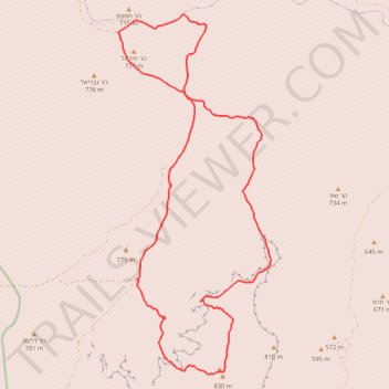
Karkom - Hispas
הר כרכום להר חספס: מסלול 8 דרך באר כרכום ובלי מילה על הסנה הבוער
- Distance: 28.7 Km
- Elevation gain: 710 m
- Maximum elevation: 825 m
- Elevation loss: 710 m
- Minimum elevation: 538 m
- Moving time: 8 h 36 s
- Moving speed: 3.6 Km/h
- Maximum speed: 4.1 Km/h
- Total time: 8 h 36 s
- Global speed: 3.6 Km/h
Interactive trail map
Trail profile
- Distance: 28.7 Km
- Elevation gain: 710 m
- Maximum elevation: 825 m
- Elevation loss: 710 m
- Minimum elevation: 538 m
- Moving time: 8 h 36 s
- Moving speed: 3.6 Km/h
- Maximum speed: 4.1 Km/h
- Total time: 8 h 36 s
- Global speed: 3.6 Km/h
About this trail
Name: Karkom - Hispas trail, distance, elevation, map, profile, GPS track
Coordinates: 30.28708 34.71537 30.37163 34.75700
Other hiking, mountain biking, running and outdoor activity trails
Click on a trail to view its statistics, map and profile.
Mount Karkom - White Canyon
Israel > South District > Hevel Eilot Regional Council
הר כרכום והקניון הלבן: סכין כרכום ואולי טבילה בקניון הלבן
Distance: 34.1 Km • Elevation gain: 783 m • Maximum elevation: 823 m
Mount Arif - Mount Karkom
Israel > South District > Ramat Negev Regional Council
הר עריף להר כרכום: הכי מרוחק ופראי שיש
Distance: 34.5 Km • Elevation gain: 1,036 m • Maximum elevation: 930 m