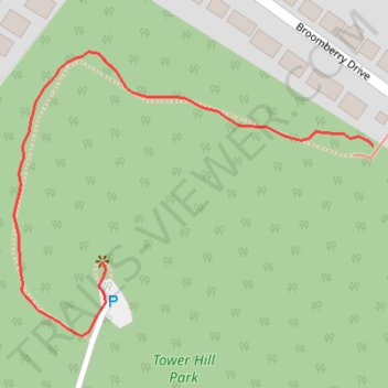
Tower Hill Park
- Distance: 0.5 Km
- Elevation gain: 55 m
- Maximum elevation: 90 m
- Elevation loss: 8 m
- Minimum elevation: 39 m
- Moving time: 9 m 13 s
- Moving speed: 3.4 Km/h
- Maximum speed: 5.6 Km/h
- Total time: 11 m 19 s
- Global speed: 2.8 Km/h
Interactive trail map
Trail profile
- Distance: 0.5 Km
- Elevation gain: 55 m
- Maximum elevation: 90 m
- Elevation loss: 8 m
- Minimum elevation: 39 m
- Moving time: 9 m 13 s
- Moving speed: 3.4 Km/h
- Maximum speed: 5.6 Km/h
- Total time: 11 m 19 s
- Global speed: 2.8 Km/h
About this trail
Name: Tower Hill Park trail, distance, elevation, map, profile, GPS track
End: Barrhill Road, Midton, Gourock, Inverclyde, Scotland, PA19 1NL, United Kingdom (55.95672 -4.82224)
Coordinates: 55.95626 -4.82321 55.95803 -4.81922
Other hiking, mountain biking, running and outdoor activity trails
Click on a trail to view its statistics, map and profile.