Thank you for supporting this site ❤️
Make a donation
Make a donation
Gear up for your next adventure:
As an Amazon Associate, this site earns from qualifying purchases at no extra cost to you.
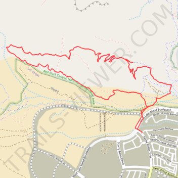
Summerlin Secret Menu Loop via Lake Mead
- Distance: 7.5 Km
- Elevation gain: 287 m
- Maximum elevation: 1,239 m
- Elevation loss: 288 m
- Minimum elevation: 1,029 m
- Moving time: 1 h 51 m
- Moving speed: 4.0 Km/h
- Maximum speed: 8.2 Km/h
- Total time: 1 h 51 m
- Global speed: 4.0 Km/h
Interactive trail map
Thank you for supporting this site ❤️
Make a donation
Make a donation
Gear up for your next adventure:
As an Amazon Associate, this site earns from qualifying purchases at no extra cost to you.
Trail profile
- Distance: 7.5 Km
- Elevation gain: 287 m
- Maximum elevation: 1,239 m
- Elevation loss: 288 m
- Minimum elevation: 1,029 m
- Moving time: 1 h 51 m
- Moving speed: 4.0 Km/h
- Maximum speed: 8.2 Km/h
- Total time: 1 h 51 m
- Global speed: 4.0 Km/h
Thank you for supporting this site ❤️
Make a donation
Make a donation
Gear up for your next adventure:
As an Amazon Associate, this site earns from qualifying purchases at no extra cost to you.
About this trail
Name: Summerlin Secret Menu Loop via Lake Mead trail, distance, elevation, map, profile, GPS track
Coordinates: 36.20494 -115.37163 36.21485 -115.34872
Thank you for supporting this site ❤️
Make a donation
Make a donation
Gear up for your next adventure:
As an Amazon Associate, this site earns from qualifying purchases at no extra cost to you.