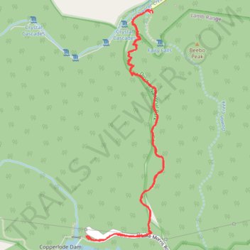
Crystal Cascades to Copperlode Dam Track
- Distance: 6.8 Km
- Elevation gain: 457 m
- Maximum elevation: 461 m
- Elevation loss: 455 m
- Minimum elevation: 66 m
- Moving time: 2 h 25 m
- Moving speed: 2.8 Km/h
- Maximum speed: 5.7 Km/h
- Total time: 3 h 4 m
- Global speed: 2.2 Km/h
Interactive trail map
Trail profile
- Distance: 6.8 Km
- Elevation gain: 457 m
- Maximum elevation: 461 m
- Elevation loss: 455 m
- Minimum elevation: 66 m
- Moving time: 2 h 25 m
- Moving speed: 2.8 Km/h
- Maximum speed: 5.7 Km/h
- Total time: 3 h 4 m
- Global speed: 2.2 Km/h
About this trail
Name: Crystal Cascades to Copperlode Dam Track trail, distance, elevation, map, profile, GPS track
Coordinates: -16.97997 145.67458 -16.96201 145.68090
Topography: Cairns topographic map, elevation, terrain
Other hiking, mountain biking, running and outdoor activity trails
Click on a trail to view its statistics, map and profile.