Maple Leaf & Kingfisher Natural Area Loop
- Distance: 4.8 Km
- Elevation gain: 111 m
- Maximum elevation: 136 m
- Elevation loss: 113 m
- Minimum elevation: 46 m
- Moving time: 35 m 42 s
- Moving speed: 8.1 Km/h
- Maximum speed: 14.3 Km/h
- Total time: 35 m 42 s
- Global speed: 8.1 Km/h
Interactive trail map
Trail profile
- Distance: 4.8 Km
- Elevation gain: 111 m
- Maximum elevation: 136 m
- Elevation loss: 113 m
- Minimum elevation: 46 m
- Moving time: 35 m 42 s
- Moving speed: 8.1 Km/h
- Maximum speed: 14.3 Km/h
- Total time: 35 m 42 s
- Global speed: 8.1 Km/h
About this trail
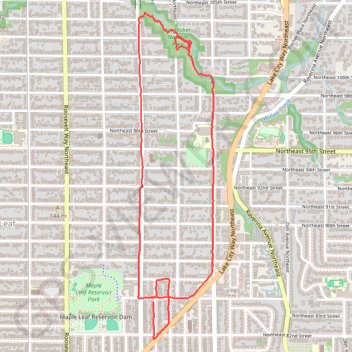
Name: Maple Leaf & Kingfisher Natural Area Loop trail, distance, elevation, map, profile, GPS track
Coordinates: 47.68833 -122.31238 47.70430 -122.30689
Other hiking, mountain biking, running and outdoor activity trails
Click on a trail to view its statistics, map and profile.
Maple Leaf & Thornton Creek Loop
United States > Washington > King County > Seattle
Distance: 7.7 Km • Elevation gain: 119 m • Maximum elevation: 135 m
Biking around Seattle
United States > Washington > King County > Seattle
Distance: 47.6 Km • Elevation gain: 407 m • Maximum elevation: 55 m