Starved Rock State Park Loop via Starved Rock, Lovers Leap Overlook, Eagle Cliff Overlook, Beehive Overlook, Lonetree Canyon, LaSalle Canyon, Sandstone Point Overlook, Wildcat Canyon Waterfall, French Canyon and Campanula Trail
This loop hike through Starved Rock State Park offers a diverse and scenic experience, showcasing stunning overlooks like Lovers Leap and Eagle Cliff, where the expansive views of the Illinois River are breathtaking. The trail meanders through lush canyons, such as LaSalle and Wildcat, where cascading waterfalls and unique sandstone formations create a tranquil atmosphere, especially after rainfall. As you navigate the various elevations and terrains, the park's rich natural beauty and wildlife will keep your spirit uplifted throughout the hike. #Hiking #Loop #Canyon #Waterfall #Forest #River #Nature
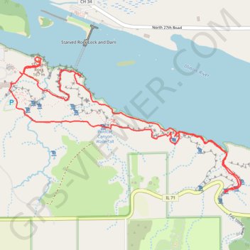
- Distance: 7.2 Km
- Elevation gain: 220 m
- Maximum elevation: 185 m
- Elevation loss: 220 m
- Minimum elevation: 144 m
- Moving time: 1 h 45 m
- Moving speed: 4.1 Km/h
- Maximum speed: 7.6 Km/h
- Total time: 1 h 47 m
- Global speed: 4.0 Km/h
Interactive trail map
Trail profile
- Distance: 7.2 Km
- Elevation gain: 220 m
- Maximum elevation: 185 m
- Elevation loss: 220 m
- Minimum elevation: 144 m
- Moving time: 1 h 45 m
- Moving speed: 4.1 Km/h
- Maximum speed: 7.6 Km/h
- Total time: 1 h 47 m
- Global speed: 4.0 Km/h
About this trail
Name: Starved Rock State Park Loop via Starved Rock, Lovers Leap Overlook, Eagle Cliff Overlook, Beehive Overlook, Lonetree Canyon, LaSalle Canyon, Sandstone Point Overlook, Wildcat Canyon Waterfall, French Canyon and Campanula Trail trail, distance, elevation, map, profile, GPS track
Start: Canada Yew, 160 stairs, LaSalle County, Illinois, 61373, United States (41.32034 -88.99209)
End: 160 stairs, LaSalle County, Illinois, 61373, United States (41.32029 -88.99190)
Coordinates: 41.31109 -88.99314 41.32151 -88.96954
Other hiking, mountain biking, running and outdoor activity trails
Click on a trail to view its statistics, map and profile.
Starved Rock State Park Loop via Wildcat Canyon Waterfall, Sandstone Point Overlook, LaSalle Canyon, Beehive Overlook, Eagle Cliff Overlook and Lovers Leap Overlook
United States > Illinois > LaSalle County
This loop hike through Starved Rock State Park, featuring Wildcat Canyon Waterfall, LaSalle Canyon, and several overlooks, offers a rich blend of natural beauty. Hikers will encounter stunning waterfalls, striking sandstone cliffs, and panoramic views of the Illinois River. Each stop, from the serene LaSalle…
Distance: 7.1 Km • Elevation gain: 193 m • Maximum elevation: 183 m
Starved Rock State Park Loop via Starved Rock, Lovers Leap Overlook, Eagle Cliff Overlook, Beehive Overlook, Wildcat Canyon and Pontiac Canyon
United States > Illinois > LaSalle County
This scenic loop hike through Starved Rock State Park offers a series of rewarding overlooks, each with its own panoramic views of the Illinois River and sandstone cliffs. Starting at Starved Rock, the route takes you through several notable spots like Lovers Leap and Eagle Cliff, where sweeping views of the…
Distance: 4.1 Km • Elevation gain: 119 m • Maximum elevation: 178 m