Great Falls Overlook via Chesapeake and Ohio Canal Trail
The Chesapeake and Ohio Canal Trail offers a delightful mix of historical and natural features, making it an appealing hike for those in the Potomac area. The trail leads to an exceptional vantage point, where hikers can witness the dramatic Great Falls, where the Potomac River drops over 60 feet, creating a series of powerful cascades. Along the way, visitors also experience lush forested landscapes, views of the canal's historic remnants, and a sense of tranquility that contrasts with the rushing water. #Hiking #Waterfall #River #Forest #Nature
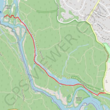
- Distance: 6.7 Km
- Elevation gain: 71 m
- Maximum elevation: 47 m
- Elevation loss: 71 m
- Minimum elevation: 29 m
- Moving time: 1 h 36 m
- Moving speed: 4.2 Km/h
- Maximum speed: 6.3 Km/h
- Total time: 1 h 53 m
- Global speed: 3.6 Km/h
Interactive trail map
Trail profile
- Distance: 6.7 Km
- Elevation gain: 71 m
- Maximum elevation: 47 m
- Elevation loss: 71 m
- Minimum elevation: 29 m
- Moving time: 1 h 36 m
- Moving speed: 4.2 Km/h
- Maximum speed: 6.3 Km/h
- Total time: 1 h 53 m
- Global speed: 3.6 Km/h
About this trail
Name: Great Falls Overlook via Chesapeake and Ohio Canal Trail trail, distance, elevation, map, profile, GPS track
Coordinates: 38.98135 -77.25197 38.99717 -77.22623
Other hiking, mountain biking, running and outdoor activity trails
Click on a trail to view its statistics, map and profile.
Bear Island Loop via Chesapeake and Ohio Canal Trail and Billy Goat Trail Section A
United States > Maryland > Montgomery County > Potomac
The Bear Island Loop, accessed via the Chesapeake and Ohio Canal Trail and Billy Goat Trail Section A, offers a combination of scenic beauty and challenging terrain. The route starts along the C&O Canal Towpath, where hikers are treated to tranquil water views and glimpses of the surrounding forest. As the…
Distance: 6.4 Km • Elevation gain: 90 m • Maximum elevation: 56 m
Bear Island Loop via Chesapeake and Ohio Canal Trail and Billy Goat Trail
United States > Maryland > Montgomery County > Potomac
The Bear Island Loop offers hikers a dynamic mix of terrain with scenic views of the Potomac River. Along the route, you'll encounter sections of peaceful canal pathways, rugged rock scrambles, and sweeping vistas of Mather Gorge. The trail's natural beauty is complemented by opportunities for exploration,…
Distance: 6.1 Km • Elevation gain: 87 m • Maximum elevation: 52 m
Great Falls Overlook and Bear Isand Loop via Billy Goat Trail and Chesapeake and Ohio Canal Trail
United States > Maryland > Montgomery County > Potomac
This loop hike offers a diverse experience, combining the rugged adventure of the Billy Goat Trail with the peaceful ambiance of the C&O Canal Trail. The Billy Goat Trail (Section A) is particularly notable for its rock scrambles and dramatic views of the Potomac River and Mather Gorge, providing a thrilling,…
Distance: 8.1 Km • Elevation gain: 91 m • Maximum elevation: 59 m
Great Falls Overlook, Billy Goat Trail, and Chesapeak and Ohio Canal Trail Loop
United States > Maryland > Montgomery County
The Great Falls Overlook, Billy Goat Trail, and Chesapeake and Ohio Canal Trail Loop offers hikers a dynamic experience featuring the powerful cascades of Great Falls, the rugged terrain of the Billy Goat Trail with its rock scrambles along Mather Gorge, and the tranquil, historic path of the C&O Canal…
Distance: 7.3 Km • Elevation gain: 86 m • Maximum elevation: 56 m