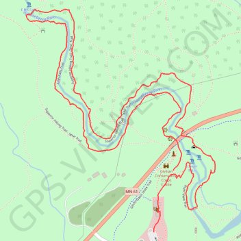
Fifth Falls Trail, Superior Hiking Trail and River View Trail Loop in Gooseberry Falls State Park
This loop offers a rich blend of scenic landscapes and tranquility. Hikers are treated to diverse views of the park's iconic waterfalls, including the quieter Fifth Falls, as well as peaceful stretches along the Gooseberry River, which contrasts with the more crowded upper falls. The trails wind through lush forests, offering opportunities for wildlife sightings and peaceful moments by the river, making it an ideal choice for those seeking a balance of adventure and serenity. #Hiking #Loop #Waterfall #River #Forest #Nature
- Distance: 4.7 Km
- Elevation gain: 78 m
- Maximum elevation: 254 m
- Elevation loss: 80 m
- Minimum elevation: 185 m
- Moving time: 1 h 37 m
- Moving speed: 2.9 Km/h
- Maximum speed: 18.9 Km/h
- Total time: 2 h 3 m
- Global speed: 2.3 Km/h
Interactive trail map
Trail profile
- Distance: 4.7 Km
- Elevation gain: 78 m
- Maximum elevation: 254 m
- Elevation loss: 80 m
- Minimum elevation: 185 m
- Moving time: 1 h 37 m
- Moving speed: 2.9 Km/h
- Maximum speed: 18.9 Km/h
- Total time: 2 h 3 m
- Global speed: 2.3 Km/h
About this trail
Name: Fifth Falls Trail, Superior Hiking Trail and River View Trail Loop in Gooseberry Falls State Park trail, distance, elevation, map, profile, GPS track
Start: River View Trail, Silver Creek Township, Lake County, Minnesota, United States (47.14224 -91.46879)
Coordinates: 47.13980 -91.47736 47.14862 -91.46636