Avalanche Lake Trail in Glacier National Park
The Avalanche Lake Trail is a stunning hike that offers a blend of forested serenity, rugged mountain views, and dramatic waterfalls. As you follow the trail, you'll pass through lush woods and cross bridges with captivating views of Avalanche Creek, before reaching the lake nestled between towering peaks like Bearhat Mountain and Little Matterhorn. The lake, fed by the melting snow and glaciers above, is surrounded by multiple waterfalls, creating a striking and peaceful scene perfect for photography and reflection. #Hiking #Mountain #Forest #Nature #Lake #Waterfall
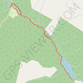
- Distance: 9.6 Km
- Elevation gain: 332 m
- Maximum elevation: 1,219 m
- Elevation loss: 333 m
- Minimum elevation: 1,040 m
Interactive trail map
Trail profile
- Distance: 9.6 Km
- Elevation gain: 332 m
- Maximum elevation: 1,219 m
- Elevation loss: 333 m
- Minimum elevation: 1,040 m
About this trail
Name: Avalanche Lake Trail in Glacier National Park trail, distance, elevation, map, profile, GPS track
Start: Going-to-the-Sun Road, Flathead County, Montana, United States (48.67978 -113.81939)
End: Going-to-the-Sun Road, Flathead County, Montana, United States (48.67904 -113.81977)
Coordinates: 48.65155 -113.81977 48.68073 -113.78419
Other hiking, mountain biking, running and outdoor activity trails
Click on a trail to view its statistics, map and profile.
Avalanche Lake
United States > Montana > Flathead County
Starting from the Avalanche area, the route first follows the shaded Trail of the Cedars through old-growth cedar and hemlock forest beside Avalanche Creek, where the water has carved the narrow and lively passage of Avalanche Gorge. Beyond the gorge, the Avalanche Lake Trail leaves the boardwalk and climbs…
Distance: 9.5 Km • Elevation gain: 329 m • Maximum elevation: 1,219 m
Trail of the Cedars Loop in Glacier National Park
United States > Montana > Flathead County
The Trail of the Cedars Loop is a delightful stroll through a lush, ancient forest, where towering Western Hemlocks and Red Cedars create a serene canopy overhead. As you meander along the accessible boardwalk, don't miss the breathtaking views from the footbridge over Avalanche Creek, where the rushing water…
Distance: 1.6 Km • Elevation gain: 31 m • Maximum elevation: 1,071 m
Loop Trail of the Cedars in Glacier National Park
United States > Montana > Flathead County
The Trail of the Cedars in Glacier National Park offers an enchanting experience, guiding visitors through an ancient forest of towering western red cedars. Along the short, accessible loop, hikers are treated to views of lush green foliage, the rushing waters of Avalanche Creek, and the smooth rock walls…
Distance: 1.3 Km • Elevation gain: 30 m • Maximum elevation: 1,071 m
Avalanche Lake Trail in Glacier National Park
United States > Montana > Flathead County
The Avalanche Lake Trail is an absolute delight for nature lovers! As you hike through towering cedar trees and lush moss-covered paths, you'll enjoy the soothing sounds of Avalanche Creek beside you. The grand reveal at the lake features stunning turquoise waters framed by majestic mountains and cascading…
Distance: 10.0 Km • Elevation gain: 300 m • Maximum elevation: 1,220 m