Mount Umunhum Trail via Guadalupe Creek Overlook in Sierra Azul Open Space Preserve
The Mount Umunhum Trail via the Guadalupe Creek Overlook offers hikers a varied and rewarding experience, showcasing a range of ecosystems from oak woodlands to chaparral scrub. Along the route, visitors are treated to expansive views of the Santa Clara Valley and surrounding mountain ranges, with notable sights such as Mount Hamilton and the distinctive radar cube at the summit. The trail provides a moderate challenge with some steep sections, but the panoramic vistas and serene landscapes make the effort worthwhile. #Hiking #Mountain #Forest #Nature #Overlook
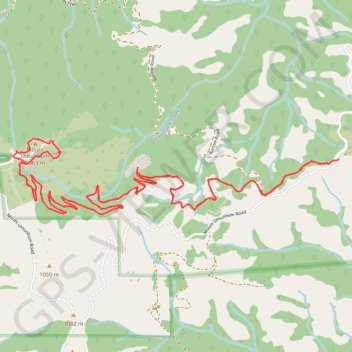
- Distance: 12.7 Km
- Elevation gain: 598 m
- Maximum elevation: 1,048 m
- Elevation loss: 604 m
- Minimum elevation: 688 m
- Moving time: 3 h 2 m
- Moving speed: 4.2 Km/h
- Maximum speed: 9.9 Km/h
- Total time: 3 h 44 m
- Global speed: 3.4 Km/h
Interactive trail map
Trail profile
- Distance: 12.7 Km
- Elevation gain: 598 m
- Maximum elevation: 1,048 m
- Elevation loss: 604 m
- Minimum elevation: 688 m
- Moving time: 3 h 2 m
- Moving speed: 4.2 Km/h
- Maximum speed: 9.9 Km/h
- Total time: 3 h 44 m
- Global speed: 3.4 Km/h
About this trail
Name: Mount Umunhum Trail via Guadalupe Creek Overlook in Sierra Azul Open Space Preserve trail, distance, elevation, map, profile, GPS track
Start: Mount Umunhum Trail, Santa Clara County, California, United States (37.15916 -121.87631)
Coordinates: 37.15610 -121.90051 37.16075 -121.87553
Other hiking, mountain biking, running and outdoor activity trails
Click on a trail to view its statistics, map and profile.
Mount Umunhum
United States > California > Santa Clara County > Peckham Ranch
Starting at Bald Mountain Parking Area in Sierra Azul Open Space Preserve, the route follows Mount Umunhum Trail westward through mixed chaparral, knobcone pine, coast live oak, California bay, and madrone, with openings toward Santa Clara Valley and the surrounding ridges. The itinerary then passes the…
Distance: 12.1 Km • Elevation gain: 633 m • Maximum elevation: 1,046 m