Thank you for supporting this site ❤️
Make a donation
Make a donation
Gear up for your next adventure:
🆘Personal Locator Beacons (PLB) - Satellite emergency beacons for life-saving help in areas with no mobile coverage
As an Amazon Associate, this site earns from qualifying purchases at no extra cost to you.
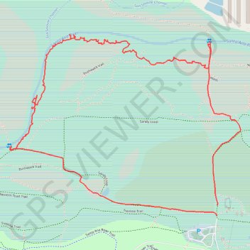
Hidden Valley bushwalk
- Distance: 4.9 Km
- Elevation gain: 9 m
- Maximum elevation: 199 m
- Elevation loss: 10 m
- Minimum elevation: 192 m
- Moving time: 1 h 30 m
- Moving speed: 3.3 Km/h
- Maximum speed: 6.1 Km/h
- Total time: 2 h 1 m
- Global speed: 2.4 Km/h
Interactive trail map
Thank you for supporting this site ❤️
Make a donation
Make a donation
Gear up for your next adventure:
As an Amazon Associate, this site earns from qualifying purchases at no extra cost to you.
Trail profile
- Distance: 4.9 Km
- Elevation gain: 9 m
- Maximum elevation: 199 m
- Elevation loss: 10 m
- Minimum elevation: 192 m
- Moving time: 1 h 30 m
- Moving speed: 3.3 Km/h
- Maximum speed: 6.1 Km/h
- Total time: 2 h 1 m
- Global speed: 2.4 Km/h
Thank you for supporting this site ❤️
Make a donation
Make a donation
Gear up for your next adventure:
As an Amazon Associate, this site earns from qualifying purchases at no extra cost to you.
About this trail
Name: Hidden Valley bushwalk trail, distance, elevation, map, profile, GPS track
Coordinates: 33.96396 -117.51574 33.97267 -117.50233
Thank you for supporting this site ❤️
Make a donation
Make a donation
Gear up for your next adventure:
As an Amazon Associate, this site earns from qualifying purchases at no extra cost to you.