Thank you for supporting this site ❤️
Make a donation
Make a donation
Gear up for your next adventure:
As an Amazon Associate, this site earns from qualifying purchases at no extra cost to you.
Kenosha
Ken-O-Sha Park
- Distance: 4.8 Km
- Elevation gain: 30 m
- Maximum elevation: 214 m
- Elevation loss: 30 m
- Minimum elevation: 203 m
- Moving time: 21 m 54 s
- Moving speed: 13.3 Km/h
- Maximum speed: 37.9 Km/h
- Total time: 26 m 17 s
- Global speed: 11.1 Km/h
Interactive trail map
Thank you for supporting this site ❤️
Make a donation
Make a donation
Gear up for your next adventure:
As an Amazon Associate, this site earns from qualifying purchases at no extra cost to you.
Trail profile
- Distance: 4.8 Km
- Elevation gain: 30 m
- Maximum elevation: 214 m
- Elevation loss: 30 m
- Minimum elevation: 203 m
- Moving time: 21 m 54 s
- Moving speed: 13.3 Km/h
- Maximum speed: 37.9 Km/h
- Total time: 26 m 17 s
- Global speed: 11.1 Km/h
Thank you for supporting this site ❤️
Make a donation
Make a donation
Gear up for your next adventure:
As an Amazon Associate, this site earns from qualifying purchases at no extra cost to you.
About this trail
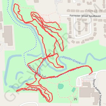
Name: Kenosha trail, distance, elevation, map, profile, GPS track
Coordinates: 42.90371 -85.63873 42.90920 -85.63270
Thank you for supporting this site ❤️
Make a donation
Make a donation
Gear up for your next adventure:
As an Amazon Associate, this site earns from qualifying purchases at no extra cost to you.