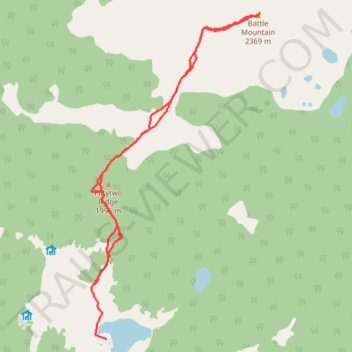
Trail to Battle Mountain
- Distance: 15.3 Km
- Elevation gain: 732 m
- Maximum elevation: 2,364 m
- Elevation loss: 744 m
- Minimum elevation: 1,852 m
- Moving time: 4 h 59 m
- Moving speed: 3.1 Km/h
- Maximum speed: 6.0 Km/h
- Total time: 6 h 47 m
- Global speed: 2.2 Km/h
Interactive trail map
Trail profile
- Distance: 15.3 Km
- Elevation gain: 732 m
- Maximum elevation: 2,364 m
- Elevation loss: 744 m
- Minimum elevation: 1,852 m
- Moving time: 4 h 59 m
- Moving speed: 3.1 Km/h
- Maximum speed: 6.0 Km/h
- Total time: 6 h 47 m
- Global speed: 2.2 Km/h
About this trail
Name: Trail to Battle Mountain trail, distance, elevation, map, profile, GPS track
Coordinates: 51.90651 -119.89298 51.95262 -119.85406