Thank you for supporting this site ❤️
Make a donation
Make a donation
Gear up for your next adventure:
As an Amazon Associate, this site earns from qualifying purchases at no extra cost to you.
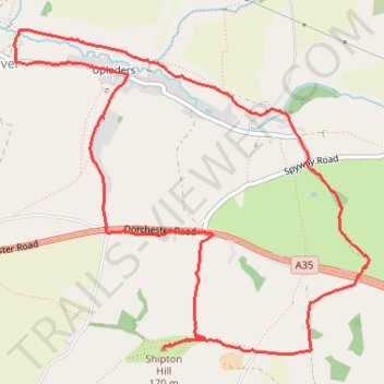
Uploders Shipton Hill Loop Run
- Distance: 8.2 Km
- Elevation gain: 183 m
- Maximum elevation: 149 m
- Elevation loss: 183 m
- Minimum elevation: 25 m
- Moving time: 50 m 54 s
- Moving speed: 9.6 Km/h
- Maximum speed: 24.7 Km/h
- Total time: 51 m 52 s
- Global speed: 9.4 Km/h
Interactive trail map
Thank you for supporting this site ❤️
Make a donation
Make a donation
Gear up for your next adventure:
As an Amazon Associate, this site earns from qualifying purchases at no extra cost to you.
Trail profile
- Distance: 8.2 Km
- Elevation gain: 183 m
- Maximum elevation: 149 m
- Elevation loss: 183 m
- Minimum elevation: 25 m
- Moving time: 50 m 54 s
- Moving speed: 9.6 Km/h
- Maximum speed: 24.7 Km/h
- Total time: 51 m 52 s
- Global speed: 9.4 Km/h
Thank you for supporting this site ❤️
Make a donation
Make a donation
Gear up for your next adventure:
⌚Altimeter Barometer Watches - Outdoor watches with built-in sensors to track altitude changes and weather shifts
As an Amazon Associate, this site earns from qualifying purchases at no extra cost to you.
About this trail
Name: Uploders Shipton Hill Loop Run trail, distance, elevation, map, profile, GPS track
Start: New Road, Uploders, Loders, Yondover, Dorset, England, DT6 4NY, United Kingdom (50.73903 -2.70438)
End: New Road, Uploders, Loders, Yondover, Dorset, England, DT6 4NY, United Kingdom (50.73903 -2.70430)
Coordinates: 50.72642 -2.71189 50.74378 -2.68188
Thank you for supporting this site ❤️
Make a donation
Make a donation
Gear up for your next adventure:
As an Amazon Associate, this site earns from qualifying purchases at no extra cost to you.