Backtrails in Bechtel Park
- Distance: 7.6 Km
- Elevation gain: 78 m
- Maximum elevation: 334 m
- Elevation loss: 77 m
- Minimum elevation: 306 m
- Moving time: 44 m 32 s
- Moving speed: 10.2 Km/h
- Maximum speed: 14.7 Km/h
- Total time: 45 m 4 s
- Global speed: 10.1 Km/h
Interactive trail map
Trail profile
- Distance: 7.6 Km
- Elevation gain: 78 m
- Maximum elevation: 334 m
- Elevation loss: 77 m
- Minimum elevation: 306 m
- Moving time: 44 m 32 s
- Moving speed: 10.2 Km/h
- Maximum speed: 14.7 Km/h
- Total time: 45 m 4 s
- Global speed: 10.1 Km/h
About this trail
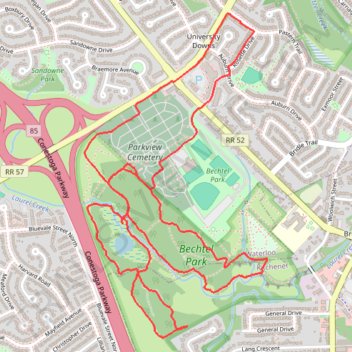
Name: Backtrails in Bechtel Park trail, distance, elevation, map, profile, GPS track
Coordinates: 43.47799 -80.49933 43.49218 -80.48836
Other hiking, mountain biking, running and outdoor activity trails
Click on a trail to view its statistics, map and profile.
Kiwanis Park trails
Canada > Ontario > Region of Waterloo > Waterloo
Distance: 10.2 Km • Elevation gain: 66 m • Maximum elevation: 334 m