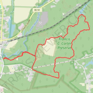
Francis C. Carter Preserve Loop Hike
- Distance: 9.1 Km
- Elevation gain: 80 m
- Maximum elevation: 57 m
- Elevation loss: 80 m
- Minimum elevation: 17 m
- Moving time: 1 h 57 m
- Moving speed: 4.6 Km/h
- Maximum speed: 7.4 Km/h
- Total time: 2 h 28 m
- Global speed: 3.7 Km/h
Interactive trail map
Trail profile
- Distance: 9.1 Km
- Elevation gain: 80 m
- Maximum elevation: 57 m
- Elevation loss: 80 m
- Minimum elevation: 17 m
- Moving time: 1 h 57 m
- Moving speed: 4.6 Km/h
- Maximum speed: 7.4 Km/h
- Total time: 2 h 28 m
- Global speed: 3.7 Km/h
About this trail
Name: Francis C. Carter Preserve Loop Hike trail, distance, elevation, map, profile, GPS track
Start: River Trail, Charlestown, South County, Rhode Island, 02894, United States (41.43238 -71.69335)
Coordinates: 41.42735 -71.69340 41.44416 -71.66300
Other hiking, mountain biking, running and outdoor activity trails
Click on a trail to view its statistics, map and profile.
River Trail and Grassland Trail loop walk at Francis C. Carter Preserve area
United States > Rhode Island > South County > Charlestown
Distance: 6.2 Km • Elevation gain: 33 m • Maximum elevation: 27 m