Thank you for supporting this site ❤️
Make a donation
Make a donation
Gear up for your next adventure:
As an Amazon Associate, this site earns from qualifying purchases at no extra cost to you.
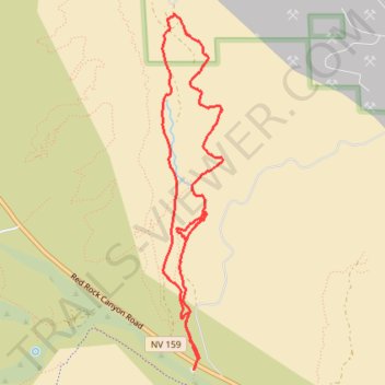
Blue Diamond Canyon loop hike from Wheeler Camp Spring Parking
- Distance: 8.3 Km
- Elevation gain: 202 m
- Maximum elevation: 1,200 m
- Elevation loss: 202 m
- Minimum elevation: 1,048 m
- Moving time: 1 h 57 m
- Moving speed: 4.2 Km/h
- Maximum speed: 6.2 Km/h
- Total time: 1 h 58 m
- Global speed: 4.2 Km/h
Interactive trail map
Thank you for supporting this site ❤️
Make a donation
Make a donation
Gear up for your next adventure:
As an Amazon Associate, this site earns from qualifying purchases at no extra cost to you.
Trail profile
- Distance: 8.3 Km
- Elevation gain: 202 m
- Maximum elevation: 1,200 m
- Elevation loss: 202 m
- Minimum elevation: 1,048 m
- Moving time: 1 h 57 m
- Moving speed: 4.2 Km/h
- Maximum speed: 6.2 Km/h
- Total time: 1 h 58 m
- Global speed: 4.2 Km/h
Thank you for supporting this site ❤️
Make a donation
Make a donation
Gear up for your next adventure:
As an Amazon Associate, this site earns from qualifying purchases at no extra cost to you.
About this trail
Name: Blue Diamond Canyon loop hike from Wheeler Camp Spring Parking trail, distance, elevation, map, profile, GPS track
Coordinates: 36.05476 -115.42197 36.08195 -115.41623
Thank you for supporting this site ❤️
Make a donation
Make a donation
Gear up for your next adventure:
As an Amazon Associate, this site earns from qualifying purchases at no extra cost to you.