Etherington - Great Divide Trail
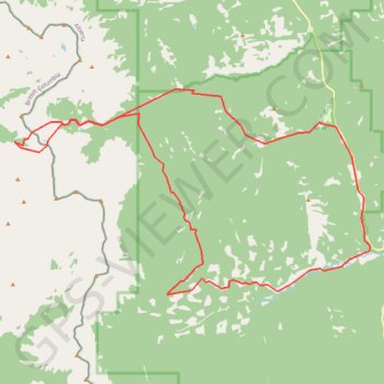
Interactive trail map
Trail profile
- Distance: 45.6 Km
- Elevation gain: 1,519 m
- Maximum elevation: 2,349 m
- Elevation loss: 1,519 m
- Minimum elevation: 1,646 m
About this trail
Name: Etherington - Great Divide Trail trail, distance, elevation, map, profile, GPS track
Start: Kananaskis Improvement District, Alberta, Canada (50.32749 -114.63255)
End: Kananaskis Improvement District, Alberta, Canada (50.32741 -114.63207)
Coordinates: 50.26550 -114.80491 50.33957 -114.60417
Other hiking, mountain biking, running and outdoor activity trails
Click on a trail to view its statistics, map and profile.
Etherington Creek, Great Divide, Baril Creek, Baril Loop
Canada > Alberta > Kananaskis Improvement District
Distance: 22.0 Km • Elevation gain: 617 m • Maximum elevation: 2,073 m
Fording River Pass Trail from Etherington Campground
Canada > Alberta > Kananaskis Improvement District
Distance: 30.7 Km • Elevation gain: 1,068 m • Maximum elevation: 2,321 m