Make a donation
Gear up for your next adventure:
As an Amazon Associate, this site earns from qualifying purchases at no extra cost to you.
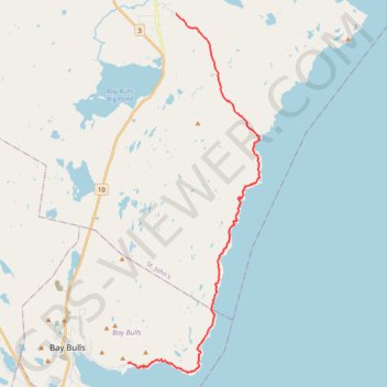
East Coast Trail - Spout Path
#Hiking #Newfoundland #Atlantic
- Distance: 22.0 Km
- Elevation gain: 854 m
- Maximum elevation: 180 m
- Elevation loss: 923 m
- Minimum elevation: 2 m
Interactive trail map
Make a donation
Gear up for your next adventure:
As an Amazon Associate, this site earns from qualifying purchases at no extra cost to you.
Trail profile
- Distance: 22.0 Km
- Elevation gain: 854 m
- Maximum elevation: 180 m
- Elevation loss: 923 m
- Minimum elevation: 2 m
Make a donation
Gear up for your next adventure:
As an Amazon Associate, this site earns from qualifying purchases at no extra cost to you.
About this trail
Name: East Coast Trail - Spout Path trail, distance, elevation, map, profile, GPS track
Start: Shoal Bay Road, St. John's, Newfoundland, Newfoundland and Labrador, Canada (47.43618 -52.75925)
Coordinates: 47.30853 -52.78494 47.43618 -52.71527
Make a donation
Gear up for your next adventure:
As an Amazon Associate, this site earns from qualifying purchases at no extra cost to you.
Other hiking, mountain biking, running and outdoor activity trails
Click on a trail to view its statistics, map and profile.
Whitbourne - St. John's
Canada > Newfoundland and Labrador > Whitbourne
#Bike #Whitbourne #StJohns #Newfoundland #Atlantic
Distance: 103.3 Km • Elevation gain: 1,230 m • Maximum elevation: 234 m