Ropley roads & rails
- Distance: 10.5 Km
- Elevation gain: 174 m
- Maximum elevation: 185 m
- Elevation loss: 160 m
- Minimum elevation: 94 m
- Moving time: 1 h 1 m
- Moving speed: 10.3 Km/h
- Maximum speed: 17.7 Km/h
- Total time: 1 h 2 m
- Global speed: 10.2 Km/h
Interactive trail map
Trail profile
- Distance: 10.5 Km
- Elevation gain: 174 m
- Maximum elevation: 185 m
- Elevation loss: 160 m
- Minimum elevation: 94 m
- Moving time: 1 h 1 m
- Moving speed: 10.3 Km/h
- Maximum speed: 17.7 Km/h
- Total time: 1 h 2 m
- Global speed: 10.2 Km/h
About this trail
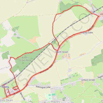
Name: Ropley roads & rails trail, distance, elevation, map, profile, GPS track
Coordinates: 51.08411 -1.10312 51.10702 -1.06528