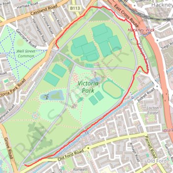
Running Victoria Park
- Distance: 2.4 Km
- Elevation gain: 9 m
- Maximum elevation: 18 m
- Elevation loss: 10 m
- Minimum elevation: 11 m
- Moving time: 13 m 54 s
- Moving speed: 10.4 Km/h
- Maximum speed: 16.6 Km/h
- Total time: 15 m 1 s
- Global speed: 9.6 Km/h
Interactive trail map
Trail profile
- Distance: 2.4 Km
- Elevation gain: 9 m
- Maximum elevation: 18 m
- Elevation loss: 10 m
- Minimum elevation: 11 m
- Moving time: 13 m 54 s
- Moving speed: 10.4 Km/h
- Maximum speed: 16.6 Km/h
- Total time: 15 m 1 s
- Global speed: 9.6 Km/h
About this trail
Name: Running Victoria Park trail, distance, elevation, map, profile, GPS track
Coordinates: 51.53374 -0.04074 51.54422 -0.02773
Other hiking, mountain biking, running and outdoor activity trails
Click on a trail to view its statistics, map and profile.
Northern Section of Green Link Walk from Epping Forest to Smithfield Market
United Kingdom > England > London
Distance: 17.5 Km • Elevation gain: 71 m • Maximum elevation: 46 m