Import a GPX file
👉 Easily get elevation data in JSON, GeoTIFF and KML formats using Elevation API
Thank you for supporting this site ❤️
Make a donation

Gear up for your next adventure:

As an Amazon Associate, this site earns from qualifying purchases at no extra cost to you.

Craters of the Moon roads

Craters of the Moon National Preserve. #Nature #Desert

  • Distance: 89.4 Km
  • Elevation gain: 416 m
  • Maximum elevation: 1,488 m
  • Elevation loss: 451 m
  • Minimum elevation: 1,301 m
  • Moving time: 2 h 47 m
  • Moving speed: 32.0 Km/h
  • Maximum speed: 68.2 Km/h
  • Total time: 2 h 52 m
  • Global speed: 31.2 Km/h

Interactive trail map

Trail profile

  • Distance: 89.4 Km
  • Elevation gain: 416 m
  • Maximum elevation: 1,488 m
  • Elevation loss: 451 m
  • Minimum elevation: 1,301 m
  • Moving time: 2 h 47 m
  • Moving speed: 32.0 Km/h
  • Maximum speed: 68.2 Km/h
  • Total time: 2 h 52 m
  • Global speed: 31.2 Km/h

About this trail
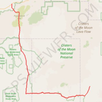
Name: Craters of the Moon roads trail, distance, elevation, map, profile, GPS track

Start: US 93;US 20;US 26, Blaine County, Idaho, United States (43.35771 -113.83712)

End: Bear Trap Cave, Minidoka To Arco Road, Blaine County, Idaho, United States (42.98409 -113.35170)

Coordinates: 42.92993 -113.83760 43.35771 -113.35125

Gear up for your next adventure:

🧼Biodegradable Outdoor Soap - Clean gear and yourself without harming the local ecosystem
🎒3L Hydration Reservoirs - Hands-free drinking to stay hydrated on steep contour climbs
👟Lightweight Trail Runners - Agile footwear for fast movement over rugged Australian terrain
🛰️Handheld GPS Units - Rugged GPS devices for tracking coordinates and elevation in the Australian bush
🧭Military Style Lensatic Compass - Durable sighting compasses for advanced land navigation and surveying

As an Amazon Associate, this site earns from qualifying purchases at no extra cost to you.