Thank you for supporting this site ❤️
Make a donation
Make a donation
Gear up for your next adventure:
⌚Altimeter Barometer Watches - Outdoor watches with built-in sensors to track altitude changes and weather shifts
As an Amazon Associate, this site earns from qualifying purchases at no extra cost to you.
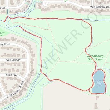
Warembourg Open Space fishing pond loop
- Distance: 1.7 Km
- Elevation gain: 14 m
- Maximum elevation: 1,657 m
- Elevation loss: 12 m
- Minimum elevation: 1,642 m
- Moving time: 17 m 35 s
- Moving speed: 5.8 Km/h
- Maximum speed: 6.5 Km/h
- Total time: 17 m 35 s
- Global speed: 5.8 Km/h
Interactive trail map
Thank you for supporting this site ❤️
Make a donation
Make a donation
Gear up for your next adventure:
As an Amazon Associate, this site earns from qualifying purchases at no extra cost to you.
Trail profile
- Distance: 1.7 Km
- Elevation gain: 14 m
- Maximum elevation: 1,657 m
- Elevation loss: 12 m
- Minimum elevation: 1,642 m
- Moving time: 17 m 35 s
- Moving speed: 5.8 Km/h
- Maximum speed: 6.5 Km/h
- Total time: 17 m 35 s
- Global speed: 5.8 Km/h
Thank you for supporting this site ❤️
Make a donation
Make a donation
Gear up for your next adventure:
As an Amazon Associate, this site earns from qualifying purchases at no extra cost to you.
About this trail
Name: Warembourg Open Space fishing pond loop trail, distance, elevation, map, profile, GPS track
Coordinates: 39.96914 -105.14903 39.97248 -105.14332
Thank you for supporting this site ❤️
Make a donation
Make a donation
Gear up for your next adventure:
As an Amazon Associate, this site earns from qualifying purchases at no extra cost to you.