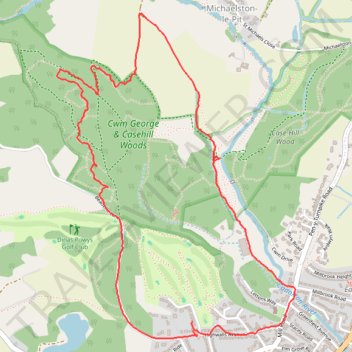
Cwm George & Casehill Woods Loop
- Distance: 5.6 Km
- Elevation gain: 115 m
- Maximum elevation: 118 m
- Elevation loss: 113 m
- Minimum elevation: 15 m
- Moving time: 1 h 24 m
- Moving speed: 3.9 Km/h
- Maximum speed: 11.8 Km/h
- Total time: 1 h 33 m
- Global speed: 3.6 Km/h
Interactive trail map
Trail profile
- Distance: 5.6 Km
- Elevation gain: 115 m
- Maximum elevation: 118 m
- Elevation loss: 113 m
- Minimum elevation: 15 m
- Moving time: 1 h 24 m
- Moving speed: 3.9 Km/h
- Maximum speed: 11.8 Km/h
- Total time: 1 h 33 m
- Global speed: 3.6 Km/h
About this trail
Name: Cwm George & Casehill Woods Loop trail, distance, elevation, map, profile, GPS track
Coordinates: 51.43480 -3.23451 51.44912 -3.21769
Other hiking, mountain biking, running and outdoor activity trails
Click on a trail to view its statistics, map and profile.
Dinas Powys West Loop Walk
United Kingdom > Wales > Vale of Glamorgan > Dinas Powys
Distance: 6.7 Km • Elevation gain: 99 m • Maximum elevation: 97 m