Wehrspann Lake Loop in Chalco Hills Recreation Area
The Wehrspann Lake Loop offers a pleasant and scenic hike around a large reservoir, surrounded by Nebraska's characteristic grasslands and wooded areas. The trail is paved, making it accessible and well-suited for both hikers and cyclists. Along the route, you can enjoy views of Wehrspann Lake, spot a variety of wildlife, and experience peaceful picnic areas and fishing spots, making it a well-rounded outdoor experience close to Omaha. #Hiking #Loop #Lake #Forest #Nature
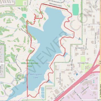
- Distance: 6.7 Km
- Elevation gain: 74 m
- Maximum elevation: 353 m
- Elevation loss: 74 m
- Minimum elevation: 333 m
- Moving time: 1 h 2 m
- Moving speed: 6.5 Km/h
- Maximum speed: 7.8 Km/h
- Total time: 1 h 2 m
- Global speed: 6.5 Km/h
Interactive trail map
Trail profile
- Distance: 6.7 Km
- Elevation gain: 74 m
- Maximum elevation: 353 m
- Elevation loss: 74 m
- Minimum elevation: 333 m
- Moving time: 1 h 2 m
- Moving speed: 6.5 Km/h
- Maximum speed: 7.8 Km/h
- Total time: 1 h 2 m
- Global speed: 6.5 Km/h
About this trail
Name: Wehrspann Lake Loop in Chalco Hills Recreation Area trail, distance, elevation, map, profile, GPS track
Start: Chalco Hills Recreation Road #1, Sarpy County, Nebraska, 68138, United States (41.17133 -96.15633)
End: Chalco Hills Recreation Road #1, Sarpy County, Nebraska, 68138, United States (41.17138 -96.15642)
Coordinates: 41.15499 -96.15834 41.17340 -96.14594