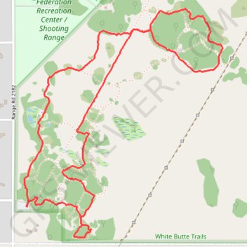
White Butte Trails
- Distance: 4.6 Km
- Elevation gain: 14 m
- Maximum elevation: 622 m
- Elevation loss: 14 m
- Minimum elevation: 613 m
- Moving time: 1 h 20 m
- Moving speed: 3.4 Km/h
- Maximum speed: 5.9 Km/h
- Total time: 1 h 30 m
- Global speed: 3.0 Km/h
Interactive trail map
Trail profile
- Distance: 4.6 Km
- Elevation gain: 14 m
- Maximum elevation: 622 m
- Elevation loss: 14 m
- Minimum elevation: 613 m
- Moving time: 1 h 20 m
- Moving speed: 3.4 Km/h
- Maximum speed: 5.9 Km/h
- Total time: 1 h 30 m
- Global speed: 3.0 Km/h
About this trail
Name: White Butte Trails trail, distance, elevation, map, profile, GPS track
Coordinates: 50.45542 -104.38807 50.46548 -104.37437
Other hiking, mountain biking, running and outdoor activity trails
Click on a trail to view its statistics, map and profile.
Regina - Indian Head
Canada > Saskatchewan > Regina
#Bike #Regina #IndianHead
Distance: 71.8 Km • Elevation gain: 165 m • Maximum elevation: 699 m