Make a donation
Gear up for your next adventure:
As an Amazon Associate, this site earns from qualifying purchases at no extra cost to you.
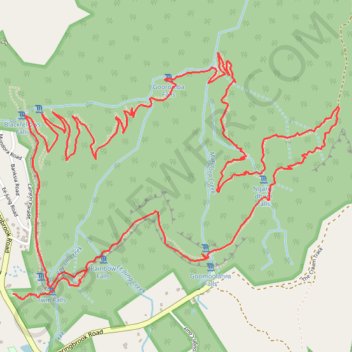
Warrie Loop Trail
Springbrook National Park. #Hiking #Loop #Springbrook
- Distance: 13.2 Km
- Elevation gain: 942 m
- Maximum elevation: 776 m
- Elevation loss: 942 m
- Minimum elevation: 358 m
Interactive trail map
Make a donation
Gear up for your next adventure:
As an Amazon Associate, this site earns from qualifying purchases at no extra cost to you.
Trail profile
- Distance: 13.2 Km
- Elevation gain: 942 m
- Maximum elevation: 776 m
- Elevation loss: 942 m
- Minimum elevation: 358 m
Make a donation
Gear up for your next adventure:
As an Amazon Associate, this site earns from qualifying purchases at no extra cost to you.
About this trail
Name: Warrie Loop Trail trail, distance, elevation, map, profile, GPS track
Start: Springbrook Road, Springbrook, Gold Coast City, Queensland, Australia (-28.22478 153.27156)
End: Springbrook Road, Springbrook, Gold Coast City, Queensland, Australia (-28.22478 153.27156)
Coordinates: -28.22508 153.27156 -28.21041 153.29357
Topography: Gold Coast City topographic map, elevation, terrain
Make a donation
Gear up for your next adventure:
As an Amazon Associate, this site earns from qualifying purchases at no extra cost to you.
Other hiking, mountain biking, running and outdoor activity trails
Click on a trail to view its statistics, map and profile.