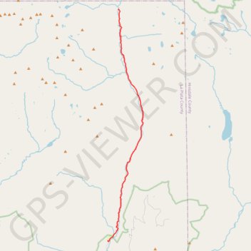
Vallecito Creek up - Weminuche Wilderness
Wilderness hike
- Distance: 20.6 Km
- Elevation gain: 724 m
- Maximum elevation: 2,942 m
- Elevation loss: 197 m
- Minimum elevation: 2,412 m
- Moving time: 6 h 14 m
- Moving speed: 3.3 Km/h
- Maximum speed: 5.8 Km/h
- Total time: 8 h 22 s
- Global speed: 2.6 Km/h
Interactive trail map
Trail profile
- Distance: 20.6 Km
- Elevation gain: 724 m
- Maximum elevation: 2,942 m
- Elevation loss: 197 m
- Minimum elevation: 2,412 m
- Moving time: 6 h 14 m
- Moving speed: 3.3 Km/h
- Maximum speed: 5.8 Km/h
- Total time: 8 h 22 s
- Global speed: 2.6 Km/h
About this trail
Name: Vallecito Creek up - Weminuche Wilderness trail, distance, elevation, map, profile, GPS track
Start: Vallecito Creek Trail Parking, La Plata County, Colorado, United States (37.47513 -107.54805)
End: Sunlight Creek Route, La Plata County, Colorado, United States (37.63139 -107.53973)
Coordinates: 37.47459 -107.54850 37.63139 -107.51842
Other hiking, mountain biking, running and outdoor activity trails
Click on a trail to view its statistics, map and profile.
Rock Lake and Moon Lake via Rock Creek Trail
United States > Colorado > San Juan County
Wilderness hike
Distance: 10.0 Km • Elevation gain: 721 m • Maximum elevation: 3,812 m
Rock Creek Down
United States > Colorado > Hinsdale County
Wilderness hike
Distance: 17.6 Km • Elevation gain: 758 m • Maximum elevation: 3,812 m