Thank you for supporting this site ❤️
Make a donation
Make a donation
Gear up for your next adventure:
As an Amazon Associate, this site earns from qualifying purchases at no extra cost to you.
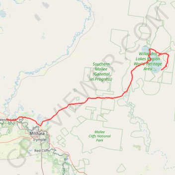
Lake Mungo National Park - Wentworth
- Distance: 180.1 Km
- Elevation gain: 486 m
- Maximum elevation: 121 m
- Elevation loss: 532 m
- Minimum elevation: 35 m
Interactive trail map
Thank you for supporting this site ❤️
Make a donation
Make a donation
Gear up for your next adventure:
As an Amazon Associate, this site earns from qualifying purchases at no extra cost to you.
Trail profile
- Distance: 180.1 Km
- Elevation gain: 486 m
- Maximum elevation: 121 m
- Elevation loss: 532 m
- Minimum elevation: 35 m
Thank you for supporting this site ❤️
Make a donation
Make a donation
Gear up for your next adventure:
As an Amazon Associate, this site earns from qualifying purchases at no extra cost to you.
About this trail
Name: Lake Mungo National Park - Wentworth trail, distance, elevation, map, profile, GPS track
Coordinates: -34.15023 141.91365 -33.64924 143.18254
Topography: Balranald Shire Council topographic map, elevation, terrain
Thank you for supporting this site ❤️
Make a donation
Make a donation
Gear up for your next adventure:
As an Amazon Associate, this site earns from qualifying purchases at no extra cost to you.