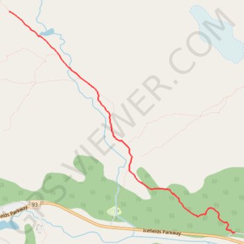
Import a GPX file

Wilcox Pass Trail

#Hiking

  • Distance: 8.2 Km
  • Elevation gain: 375 m
  • Maximum elevation: 2,351 m
  • Elevation loss: 371 m
  • Minimum elevation: 2,018 m

Interactive trail map

Trail profile

  • Distance: 8.2 Km
  • Elevation gain: 375 m
  • Maximum elevation: 2,351 m
  • Elevation loss: 371 m
  • Minimum elevation: 2,018 m

About this trail

Name: Wilcox Pass Trail trail, distance, elevation, map, profile, GPS track

Start: Wilcox Creek Campground, Improvement District No. 12, Alberta, Canada (52.21819 -117.18480)

End: Wilcox Creek Campground, Improvement District No. 12, Alberta, Canada (52.21821 -117.18446)

Coordinates: 52.21817 -117.22172 52.24057 -117.18446

Other hiking, mountain biking, running and outdoor activity trails

Click on a trail to view its statistics, map and profile.

Jasper National Park - Banff National Park

Canada > Alberta > Improvement District No. 12

#Bike #Jasper #Banff

Distance: 84.1 Km • Elevation gain: 1,174 m • Maximum elevation: 2,070 m

Gear up for your next adventure:

🎒Tactical Waist Packs - Quick access to your compass, phone, and snacks while walking
📚Map Reading & Navigation Guides - Master the art of interpreting topographic contours and symbols
🧥Thermal Emergency Blankets - Compact Mylar blankets to prevent hypothermia if stranded overnight
🔪Outdoor Multi-tools - Versatile tools for gear repair and survival tasks in the wilderness
📻Handheld UHF Radios - Critical communication for groups in the Australian outback

As an Amazon Associate, this site earns from qualifying purchases at no extra cost to you.