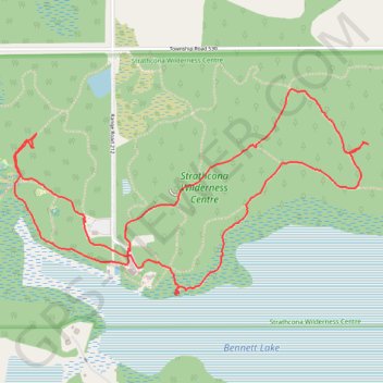
Strathcona Wilderness Center
- Distance: 5.6 Km
- Elevation gain: 37 m
- Maximum elevation: 770 m
- Elevation loss: 37 m
- Minimum elevation: 755 m
- Moving time: 1 h 11 m
- Moving speed: 4.7 Km/h
- Maximum speed: 7.8 Km/h
- Total time: 1 h 34 m
- Global speed: 3.5 Km/h
Interactive trail map
Trail profile
- Distance: 5.6 Km
- Elevation gain: 37 m
- Maximum elevation: 770 m
- Elevation loss: 37 m
- Minimum elevation: 755 m
- Moving time: 1 h 11 m
- Moving speed: 4.7 Km/h
- Maximum speed: 7.8 Km/h
- Total time: 1 h 34 m
- Global speed: 3.5 Km/h
About this trail
Name: Strathcona Wilderness Center trail, distance, elevation, map, profile, GPS track
Start: Fox Loop, Strathcona County, Alberta, T8G 2C9, Canada (53.53331 -112.99935)
End: Fox Loop, Strathcona County, Alberta, T8G 2C9, Canada (53.53335 -112.99941)
Coordinates: 53.53166 -113.00692 53.53962 -112.98378