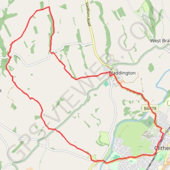
Import a GPX file

Sandy Ford

  • Distance: 14.0 Km
  • Elevation gain: 206 m
  • Maximum elevation: 208 m
  • Elevation loss: 206 m
  • Minimum elevation: 53 m

Interactive trail map

Trail profile

  • Distance: 14.0 Km
  • Elevation gain: 206 m
  • Maximum elevation: 208 m
  • Elevation loss: 206 m
  • Minimum elevation: 53 m

About this trail

Gear up for your next adventure:

🎒3L Hydration Reservoirs - Hands-free drinking to stay hydrated on steep contour climbs
☀️Portable Solar Chargers - High-efficiency panels to hang on your backpack while walking
🦟Insect Repellent - Protection against insects
🧥Packable Rain Jackets - Breathable waterproof layers for unpredictable mountain weather
📚Map Reading & Navigation Guides - Master the art of interpreting topographic contours and symbols

As an Amazon Associate, this site earns from qualifying purchases at no extra cost to you.