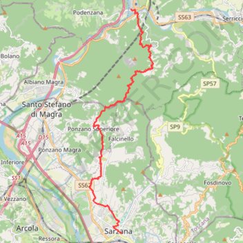
Tappa-24-da-aulla-a-sarzana
- Distance: 17.5 Km
- Elevation gain: 738 m
- Maximum elevation: 538 m
- Elevation loss: 768 m
- Minimum elevation: 24 m
Interactive trail map
Trail profile
- Distance: 17.5 Km
- Elevation gain: 738 m
- Maximum elevation: 538 m
- Elevation loss: 768 m
- Minimum elevation: 24 m
About this trail
Name: Tappa-24-da-aulla-a-sarzana trail, distance, elevation, map, profile, GPS track
End: Via Giuseppe Mazzini, Crociata, Sarzana, Follo, La Spezia, Liguria, 19038, Italy (44.11186 9.96211)
Coordinates: 44.11186 9.94314 44.20747 9.98060
Other hiking, mountain biking, running and outdoor activity trails
Click on a trail to view its statistics, map and profile.
1 LUCENA - MONTPELLIER
Distance: 2,964.4 Km • Elevation gain: 29,500 m • Maximum elevation: 1,048 m