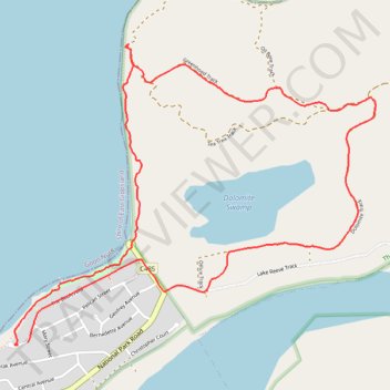
The Lakes National Park - Dolomite and Greenhood loop trails
- Distance: 7.5 Km
- Elevation gain: 61 m
- Maximum elevation: 20 m
- Elevation loss: 61 m
- Minimum elevation: -1 m
- Moving time: 1 h 49 m
- Moving speed: 4.1 Km/h
- Maximum speed: 6.3 Km/h
- Total time: 2 h 20 m
- Global speed: 3.2 Km/h
Interactive trail map
Trail profile
- Distance: 7.5 Km
- Elevation gain: 61 m
- Maximum elevation: 20 m
- Elevation loss: 61 m
- Minimum elevation: -1 m
- Moving time: 1 h 49 m
- Moving speed: 4.1 Km/h
- Maximum speed: 6.3 Km/h
- Total time: 2 h 20 m
- Global speed: 3.2 Km/h
About this trail
Name: The Lakes National Park - Dolomite and Greenhood loop trails trail, distance, elevation, map, profile, GPS track
Start: 89, The Boulevard, Loch Sport, Shire of Wellington, Victoria, 3851, Australia (-38.02993 147.60530)
End: 100, The Boulevard, Loch Sport, Shire of Wellington, Victoria, 3851, Australia (-38.03005 147.60459)
Coordinates: -38.03009 147.60442 -38.01440 147.62833
Topography: Victoria topographic map, elevation, terrain
Other hiking, mountain biking, running and outdoor activity trails
Click on a trail to view its statistics, map and profile.
Sale - Bairnsdale
#Bike
Distance: 71.9 Km • Elevation gain: 254 m • Maximum elevation: 55 m