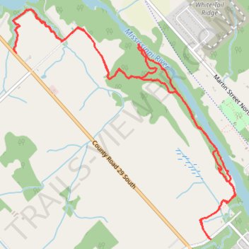
Mississippi Valley Trail - ART and Naismith Sections
Canada, ON, Almonte
- Distance: 10.9 Km
- Elevation gain: 87 m
- Maximum elevation: 122 m
- Elevation loss: 87 m
- Minimum elevation: 98 m
- Moving time: 2 h 41 m
- Moving speed: 4.0 Km/h
- Maximum speed: 7.3 Km/h
- Total time: 2 h 46 m
- Global speed: 3.9 Km/h
Interactive trail map
Trail profile
- Distance: 10.9 Km
- Elevation gain: 87 m
- Maximum elevation: 122 m
- Elevation loss: 87 m
- Minimum elevation: 98 m
- Moving time: 2 h 41 m
- Moving speed: 4.0 Km/h
- Maximum speed: 7.3 Km/h
- Total time: 2 h 46 m
- Global speed: 3.9 Km/h
About this trail
Name: Mississippi Valley Trail - ART and Naismith Sections trail, distance, elevation, map, profile, GPS track
Coordinates: 45.22575 -76.23344 45.24660 -76.20482
Other hiking, mountain biking, running and outdoor activity trails
Click on a trail to view its statistics, map and profile.