Import a GPX file

Chocorua Lake Trails

  • Distance: 6.4 Km
  • Elevation gain: 95 m
  • Maximum elevation: 227 m
  • Elevation loss: 96 m
  • Minimum elevation: 174 m

Interactive trail map

Trail profile

  • Distance: 6.4 Km
  • Elevation gain: 95 m
  • Maximum elevation: 227 m
  • Elevation loss: 96 m
  • Minimum elevation: 174 m

About this trail

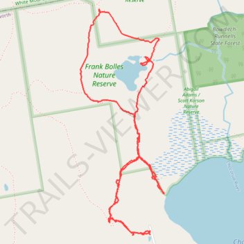
Name: Chocorua Lake Trails trail, distance, elevation, map, profile, GPS track

Start: Bolles Access Trail, Tamworth, Carroll County, New Hampshire, 03817, United States (43.90360 -71.24713)

End: 133, Bolles Road, Tamworth, Carroll County, New Hampshire, 03817, United States (43.90384 -71.24709)

Coordinates: 43.90357 -71.25335 43.91814 -71.24588

Other hiking, mountain biking, running and outdoor activity trails

Click on a trail to view its statistics, map and profile.

Québec - Montréal - Saint-Laurent River - Lake Ontario - Niagara Falls

Canada > Quebec > Urban agglomeration of Québec > Quebec

#Bike #Ontario

Distance: 1,078.4 Km • Elevation gain: 4,804 m • Maximum elevation: 209 m

Gear up for your next adventure:

🧥Down Jackets - Insulated jackets for cold weather
👄SPF Lip Balm - Prevent sun and wind-burnt lips on mountain ridges
🔦LED Torches - LED torches for outdoor use
🍴Titanium Spork & Cutlery - Indestructible and feather-light eating utensils
🥾Hiking Gaiters - Leg protection for trails

As an Amazon Associate, this site earns from qualifying purchases at no extra cost to you.