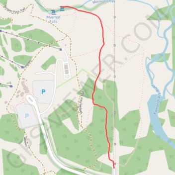
Import a GPX file

Troll Falls

#Hiking #Snowshoeing #Forest #River #Nature

  • Distance: 3.4 Km
  • Elevation gain: 72 m
  • Maximum elevation: 1,498 m
  • Elevation loss: 72 m
  • Minimum elevation: 1,439 m

Interactive trail map

Trail profile

  • Distance: 3.4 Km
  • Elevation gain: 72 m
  • Maximum elevation: 1,498 m
  • Elevation loss: 72 m
  • Minimum elevation: 1,439 m

About this trail

Name: Troll Falls trail, distance, elevation, map, profile, GPS track

Start: Kananaskis Village, Kananaskis Improvement District, Alberta, Canada (50.93649 -115.14117)

End: Kananaskis Village, Kananaskis Improvement District, Alberta, Canada (50.93648 -115.14118)

Coordinates: 50.93648 -115.14736 50.94841 -115.14117

Other hiking, mountain biking, running and outdoor activity trails

Click on a trail to view its statistics, map and profile.

Olympic Summit - Mount Allan

Canada > Alberta > Kananaskis Improvement District > Kananaskis Village

#Hiking #Loop #Olympic #Allan

Distance: 16.6 Km • Elevation gain: 1,429 m • Maximum elevation: 2,821 m

Gear up for your next adventure:

🎒40L Day Hiking Backpacks - Comfortable packs with hydration support for long days exploring topographic peaks
🛠️Outdoor Repair Kits - Gear repair kits
📚Map Reading & Navigation Guides - Master the art of interpreting topographic contours and symbols
🎨Portable Watercolor Kits - Paint the landscapes and topographic views you discover
🧼Biodegradable Outdoor Soap - Clean gear and yourself without harming the local ecosystem

As an Amazon Associate, this site earns from qualifying purchases at no extra cost to you.