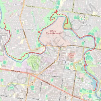
Maribyrnong River
#Hiking #Bike #Maribyrnong #Melbourne
- Distance: 14.8 Km
- Elevation gain: 141 m
- Maximum elevation: 43 m
- Elevation loss: 178 m
- Minimum elevation: 1 m
Interactive trail map
Trail profile
- Distance: 14.8 Km
- Elevation gain: 141 m
- Maximum elevation: 43 m
- Elevation loss: 178 m
- Minimum elevation: 1 m
About this trail
Name: Maribyrnong River trail, distance, elevation, map, profile, GPS track
Coordinates: -37.78889 144.85081 -37.75318 144.90359
Topography: Melbourne topographic map, elevation, terrain