Thank you for supporting this site ❤️
Make a donation
Make a donation
Gear up for your next adventure:
As an Amazon Associate, this site earns from qualifying purchases at no extra cost to you.
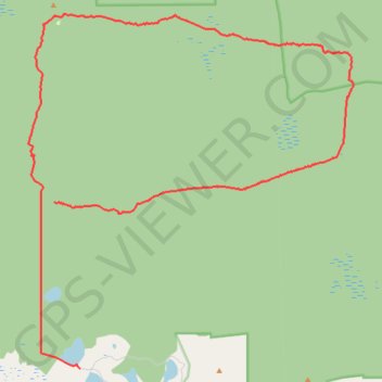
Murray-Sunset Remote Track
Murray-Sunset National Park. #Hiking #Loop #MurraySunset
- Distance: 48.3 Km
- Elevation gain: 379 m
- Maximum elevation: 111 m
- Elevation loss: 353 m
- Minimum elevation: 39 m
Interactive trail map
Thank you for supporting this site ❤️
Make a donation
Make a donation
Gear up for your next adventure:
As an Amazon Associate, this site earns from qualifying purchases at no extra cost to you.
Trail profile
- Distance: 48.3 Km
- Elevation gain: 379 m
- Maximum elevation: 111 m
- Elevation loss: 353 m
- Minimum elevation: 39 m
Thank you for supporting this site ❤️
Make a donation
Make a donation
Gear up for your next adventure:
As an Amazon Associate, this site earns from qualifying purchases at no extra cost to you.
About this trail
Name: Murray-Sunset Remote Track trail, distance, elevation, map, profile, GPS track
Start: Murray-Sunset, Rural City of Mildura, Victoria, 3490, Australia (-35.03919 141.71524)
Coordinates: -35.03919 141.69182 -34.90661 141.84052
Topography: Victoria topographic map, elevation, terrain
Thank you for supporting this site ❤️
Make a donation
Make a donation
Gear up for your next adventure:
As an Amazon Associate, this site earns from qualifying purchases at no extra cost to you.