Make a donation
Gear up for your next adventure:
As an Amazon Associate, this site earns from qualifying purchases at no extra cost to you.
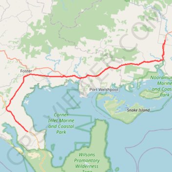
Wilsons Promontory - Yarram
#Bike
- Distance: 71.4 Km
- Elevation gain: 360 m
- Maximum elevation: 66 m
- Elevation loss: 358 m
- Minimum elevation: 3 m
Interactive trail map
Make a donation
Gear up for your next adventure:
As an Amazon Associate, this site earns from qualifying purchases at no extra cost to you.
Trail profile
- Distance: 71.4 Km
- Elevation gain: 360 m
- Maximum elevation: 66 m
- Elevation loss: 358 m
- Minimum elevation: 3 m
Make a donation
Gear up for your next adventure:
As an Amazon Associate, this site earns from qualifying purchases at no extra cost to you.
About this trail
Name: Wilsons Promontory - Yarram trail, distance, elevation, map, profile, GPS track
Start: Yanakie, Shire of South Gippsland, Victoria, 3960, Australia (-38.81215 146.20748)
Coordinates: -38.81215 146.13480 -38.56926 146.67523
Topography: Victoria topographic map, elevation, terrain
Make a donation
Gear up for your next adventure:
As an Amazon Associate, this site earns from qualifying purchases at no extra cost to you.
Other hiking, mountain biking, running and outdoor activity trails
Click on a trail to view its statistics, map and profile.
Whipstick Gully and New Zealand Hill loop hike
Distance: 3.7 Km • Elevation gain: 55 m • Maximum elevation: 81 m
Yarram - Seaspray - Sale
#Bike
Distance: 99.8 Km • Elevation gain: 375 m • Maximum elevation: 98 m