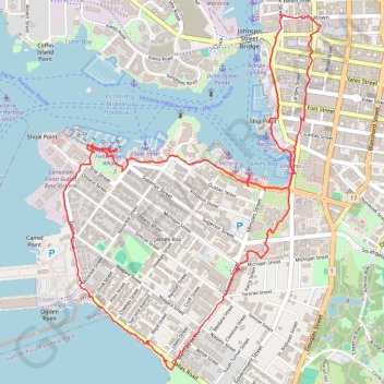
Import a GPX file

Victoria Loop

#Hiking #Loop #Victoria #Pacific

  • Distance: 8.2 Km
  • Elevation gain: 104 m
  • Maximum elevation: 29 m
  • Elevation loss: 105 m
  • Minimum elevation: 0 m

Interactive trail map

Trail profile

  • Distance: 8.2 Km
  • Elevation gain: 104 m
  • Maximum elevation: 29 m
  • Elevation loss: 105 m
  • Minimum elevation: 0 m

About this trail

Other hiking, mountain biking, running and outdoor activity trails

Click on a trail to view its statistics, map and profile.

Ogden Point Breakwater

Canada > British Columbia > Capital Regional District > Victoria

Vancouver Island. #Hiking #Running #Victoria #Vancouver

Distance: 1.4 Km • Elevation gain: 8 m • Maximum elevation: 6 m

Gear up for your next adventure:

🧼Biodegradable Outdoor Soap - Clean gear and yourself without harming the local ecosystem
🪑Portable Backpacking Chairs - A comfortable seat for studying maps at the end of the day
🚁Camera Drones with GPS - Capture aerial views of the landscape to compare with topo maps
🔪Multitools - Compact tools for outdoor use
📕Australia Maps - Maps covering Australian regions

As an Amazon Associate, this site earns from qualifying purchases at no extra cost to you.