Lake Helen
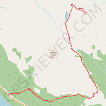
Interactive trail map
Trail profile
- Distance: 14.1 Km
- Elevation gain: 641 m
- Maximum elevation: 2,544 m
- Elevation loss: 630 m
- Minimum elevation: 1,964 m
About this trail
Name: Lake Helen trail, distance, elevation, map, profile, GPS track
Start: Icefields Parkway, Improvement District No. 9, Alberta, Canada (51.66369 -116.43963)
End: Helen Lake Trail, Improvement District No. 9, Alberta, Canada (51.66414 -116.43877)
Coordinates: 51.66176 -116.43963 51.68910 -116.39929
Other hiking, mountain biking, running and outdoor activity trails
Click on a trail to view its statistics, map and profile.