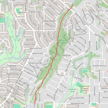
Import a GPX file

Mosquito Creek Park

#Hiking #Running #MosquitoCreek #Vancouver

  • Distance: 3.9 Km
  • Elevation gain: 159 m
  • Maximum elevation: 249 m
  • Elevation loss: 159 m
  • Minimum elevation: 89 m

Interactive trail map

Trail profile

  • Distance: 3.9 Km
  • Elevation gain: 159 m
  • Maximum elevation: 249 m
  • Elevation loss: 159 m
  • Minimum elevation: 89 m

About this trail

Other hiking, mountain biking, running and outdoor activity trails

Click on a trail to view its statistics, map and profile.

Vancouver - Golden

Canada > British Columbia > Metro Vancouver Regional District > Vancouver

#Bike #Vancouver #Golden

Distance: 827.6 Km • Elevation gain: 9,376 m • Maximum elevation: 1,347 m

Gear up for your next adventure:

🌬️Windbreaker Jackets - Wind protection jackets
🌿Flora and Fauna Field Guides - Identify the plants and animals you encounter on your route
🧭Military Style Lensatic Compass - Durable sighting compasses for advanced land navigation and surveying
GPS Watches - GPS watches for outdoor sports
🧤Thermal Hiking Gloves - Keep your hands warm and functional during high-altitude winter treks

As an Amazon Associate, this site earns from qualifying purchases at no extra cost to you.